


UPDATE (12:36 p.m. Wednesday): We have a newly updated story posted on the latest forecasts for the incoming storm. Click here for more the latest.
———
DENVER – While temperatures reached the mid-60s in Denver on Tuesday, rain and snow are moving in Wednesday afternoon, which could make for a slushy commute on Thursday morning.
The National Weather Service in Boulder issued a winter storm watch for the metro-area foothills, the foothills west of Colorado Springs, and the Palmer Divide that will start Wednesday afternoon and continue into Thursday afternoon.
In those areas, 4-10 inches of snow is possible, with possibly up to a foot at the higher elevations, according to the NWS. For parts of Teller County and Pikes Peak, 6-12 inches of snow is forecast. And northern El Paso County could see 4-8 inches of snow and wind gusts up to 35 miles per hour.
MORE: Closings and Delays | Full forecast | Radars | Traffic | Weather Page | 24/7 Weather Stream | 24/7 Radar Stream
The precipitation could start out as light rain in the metro area and along the plains on Thursday morning, which will continue through the afternoon.
According to the NWS, the rain will likely persist through 9 p.m. in the metro area, then change to a rain-snow mix between 9 p.m. Wednesday and midnight, then switch to snow overnight as another cold air mass moves into the area.
A winter system will arrive Wednesday through Thursday afternoon. Moderate snowfall for parts of the foothills and Palmer Divide. Those traveling across I-25 and I-70 south of the Denver metro should prepare for winter conditions mainly late Wednesday into Thursday morning #COwx pic.twitter.com/dMEb3YrPVH
— NWS Boulder (@NWSBoulder) March 15, 2022
For the Sangre de Cristo Mountains, Wet Mountain Valley, parts of the western Mosquito and eastern Sawatch mountains, and eastern Lake County, winter weather advisories will be in effect Wednesday into Thursday for 4-6 inches of snow at lower elevations and 6-10 inches at elevations above 8,500 feet, the NWS said.
According to the NWS, the snow line should be at around 7,000 feet to start with on Wednesday afternoon, but lower elevations should see rain switch over to snow sometime between 6 p.m. and 9 p.m. Wednesday.
By Wednesday evening, areas on I-25 south of Denver, along with the Palmer Divide, should see a rain-snow mix that switches over to snow, while further north on I-25, rain could persist later into the evening.
Models on Tuesday afternoon indicated a better upslope flow, which should boost snowfall slightly in the foothills and Palmer Divide.
The NWS said models show mostly snow Wednesday night from Boulder to Centennial and to the Palmer Divide.
The snow is expected to diminish by late Thursday morning or early Thursday afternoon, according to the NWS. For the storm, the highest snow totals are expected to be across the foothills and Palmer Divide, which could see up to a foot.
“At least a couple of inches of slushy snow is expected for Denver,” forecasters wrote on Tuesday afternoon.
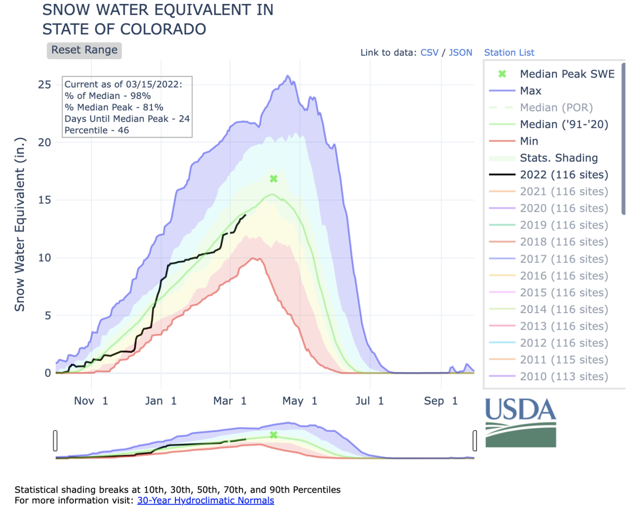
Colorado’s statewide snowpack was 98% of median as of Tuesday after a fairly steady increase over the past 10 days. The snowpack in the eight individual river basins has also improved.
The Gunnison basin has the largest snowpack in Colorado as of Tuesday, with 111% of median. The San Miguel, Dolores, Animas and San Juan (104%) and Upper Colorado Headwaters (103%) were both above median levels.
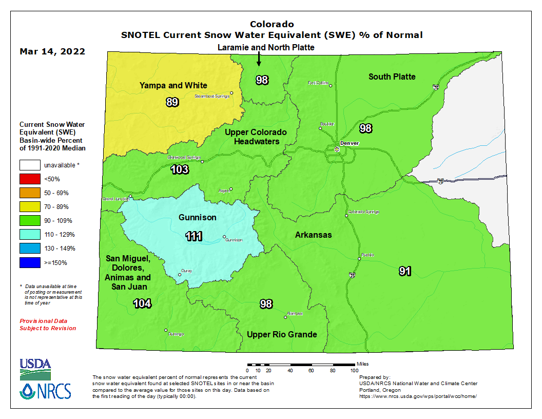
The Laramie and North Platte (98%), Upper Rio Grande (98%), and South Platte (98%) were all slightly below median levels. And the Arkansas (91%) and Yampa and White (89%) basins were slightly further below median levels.
You can always watch 24/7 weather, radar and news updates on the free Denver7+ app on your TV.


