UPDATE (Tuesday, 10:52 a.m.): The National Weather Service has upgraded the Front Range foothills to winter storm warnings and the metro area and plains to winter weather advisories ahead of the snowstorm, which is expected to hit Tuesday afternoon and continue into late Wednesday.
We have a newly updated story and forecast. Click here for the latest.
———
DENVER – Ahead of another round of snow early this week and bitterly cold temperatures, we’ll see high wind warnings in the foothills Monday before cold fronts move into the state.
While temperatures will be mild Monday, a cold front will move across the northern part of the state, bringing 35-50 mph winds to the Front Range foothills and gusts of up to 80 mph. A high wind warning is in effect from 10 a.m. to 6 p.m.
The National Weather Service in Boulder said a mountain wave could develop that could send the high winds crashing down the foothills. After the front moves through, there will be cooler temperatures and a wind shift behind it.
But Tuesday brings the biggest changes in weather for most of the eastern half of the state this week.
Temperatures are only expected to reach near freezing in Denver for high temperatures on Tuesday, and the snow is expected to start in the afternoon – first mostly in the high country before it moves down to the plains.
Monday’s forecast from the National Weather Service says the snow should be light at first Tuesday evening and moderate throughout the night through Wednesday morning. The snowfall is expected to stop by Wednesday night, when bitter cold will set in.
High temperatures Wednesday will only reach the teens on the plains and the single digits in the high country, and low temperatures are expected to fall to the single digits and below zero across much of northeastern Colorado.
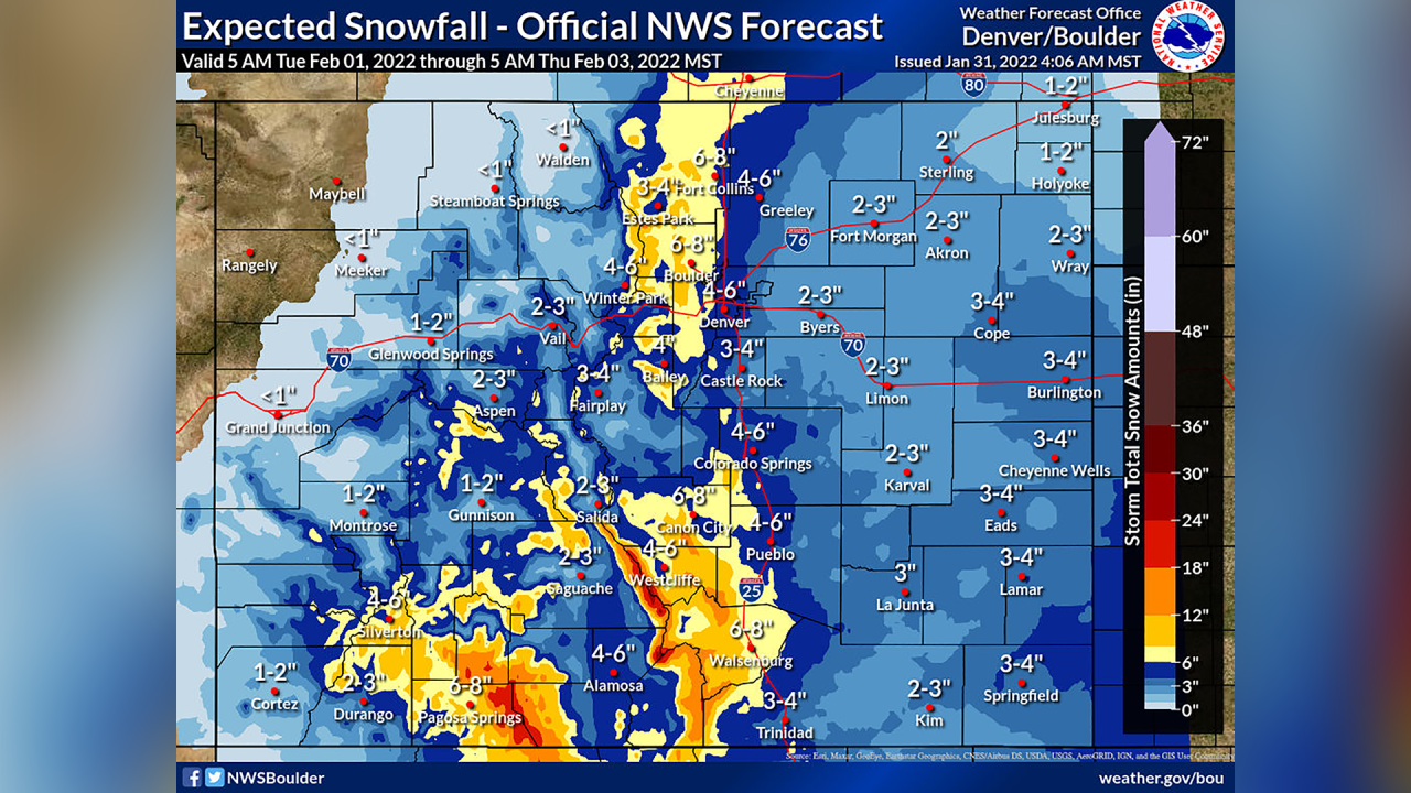
In terms of snow totals, the NWS said as of Monday models indicates about 2-5 inches on the plains, 6-12 inches on the foothills and eastern slopes of the Front Range, 3-6 inches for the western Front Range slopes, and 1-2 inches in the mountain valleys.

The latest forecast shows 4-6 inches for Denver, 6-8 inches for Boulder, 6-8 inches for Fort Collins, and 3-4 inches for Castle Rock. Denver has received 13.4 inches of snowfall so far this year.
Winter weather advisories could be issued for the I-25 corridor and foothills, as the higher totals are expected in those areas and could have the biggest effects on travel, the NWS said Monday.
Further south, winter storm watches are in effect from Tuesday afternoon through Wednesday evening for the La Garita, Sangre de Cristo and Wet Mountains for 6-18 inches of possible snow. The Pikes Peak area should see 4-10 inches, while the San Luis Valley and southeastern Colorado could see 3-6 inches.

Statewide snowpack was at 104% of median as of Monday and has leveled off through the back half of January after a snowy few weeks in the mountains in late December and early this month.
Across the state, six of the eight river basins still have above-median snowpack levels – with the Arkansas (74%) and Upper Rio Grande (86%) basins the only ones below median levels.

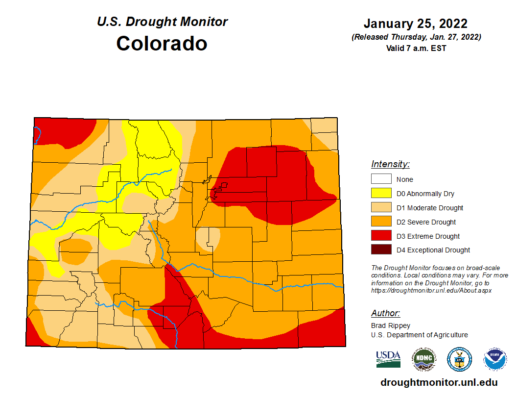
Any snow Colorado sees will continue to help boost those snowpack levels heading into the spring. All of Colorado remains under some sort of drought as of this week, and 65% of the state is seeing severe drought or worse conditions.

The Denver metro area and parts of the eastern plains are seeing extreme drought, as is the far northwestern corner of Colorado and about half of the southernmost counties in the state.
You can always watch 24/7 weather, radar and news updates on the free Denver7+ app on your TV.


