


DENVER – The Denver metro area is set for another round of about 2 to 5 inches of snow Friday afternoon into Friday night that is expected to affect the evening commute.
The National Weather Service in Boulder issued winter weather advisories for the metro area, Boulder, southern Front Range foothills and Palmer Divide that goes into effect at 2 p.m. and lasts through 11 p.m. Friday.
In the lower areas, 2-5 inches of snow are expected along with winds gusting up to 25 miles per hour.
The NWS said in an update around 10:30 a.m. that the foothills south of Boulder could see slightly higher totals, with 4-8 expected in most of the foothills in the area but up to 6-10 inches possible.
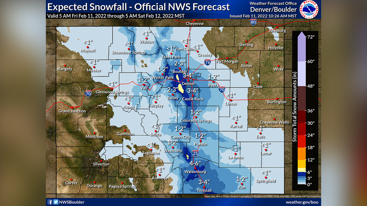
The advisories are also in effect for areas west of Colorado Springs, the Wet Mountains, and the Pueblo area.
MORE: Closings and Delays | Forecast | Radars | Traffic | Weather Page | 24/7 Weather Stream | 24/7 Radar Stream
According to the National Weather Service, the northern mountains should expect between a trace and 2 inches of snow because of northerly winds. Summit County and the I-70 mountain corridor in the area could see 1 to 4 inches of snow.
The heavier snow is expected to fall east of the Continental Divide in the Denver metro area and foothills west of Denver and Boulder, where conditions could create banded snowfall in the metro area.
“It’s likely several bands of snow will form by mid to late afternoon, with the best chance for moderate to heavy snowfall rates occurring between 4-7 p.m., though light snow should begin around noon across the northern third of the plains and I-25 corridor,” the NWS wrote in Friday morning’s forecast discussion.
The NWS said it expects the Jefferson County foothills to see the heaviest snow and that I-70 and U.S. 285 will likely be slick by sunset. The metro area should also see slick roads during the evening commute.
The snow is expected to end around midnight, and skies will clear overnight. Low temperatures will be in the teens Saturday morning on the plains and in the metro area.

While the mountains aren’t likely to see the most snow in this storm, anything helps the snowpack this time of year.
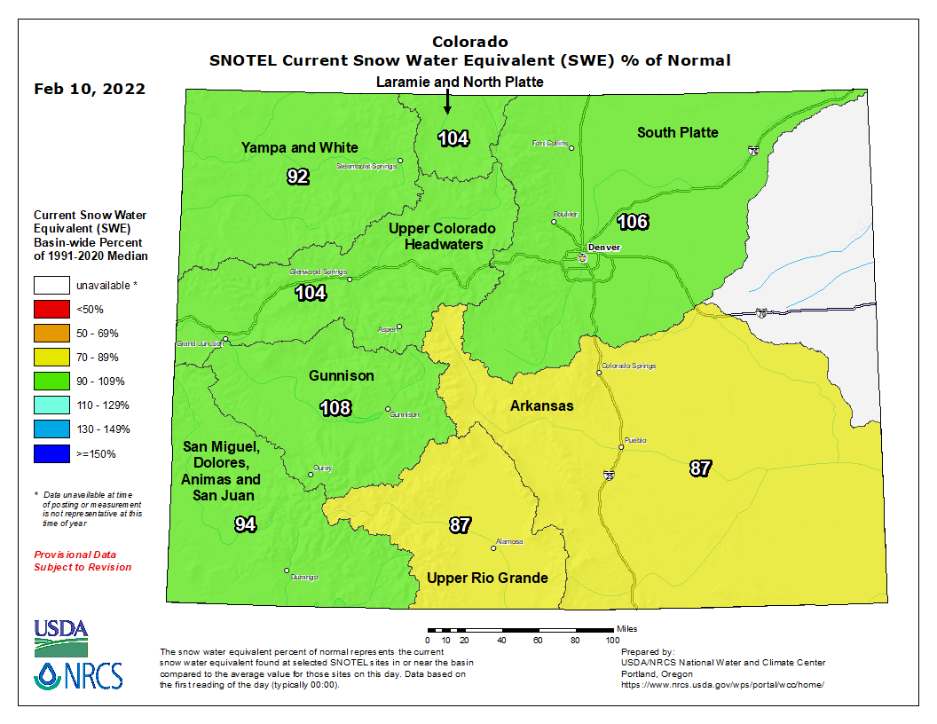
Statewide snowpack was at 97% of median as of Friday morning amid a multi-week mostly dry spell in the mountains. But several basins fell below median levels this week.
The South Platte (106%), Laramie and North Platte (104%), Upper Colorado Headwaters (104%), and Gunnison (108%) basins are all still above median levels. But the Yampa and White (92%), San Miguel, Dolores, Animas and San Juan (94%), Upper Rio Grande (87%) and Arkansas (87%) basins are below median levels.
Colorado saw a slight improvement drought-wise this week compared to last, with the percentage of the state experiencing severe drought falling from 65% last week to 62% this week and the amount of extreme drought in Colorado falling from 19% to 8.5%, according to the U.S. Drought Monitor.
You can always watch 24/7 weather, radar and news updates on the free Denver7+ app on your TV.


