DENVER — A strong blast of winter weather has moved into Colorado, bringing with it a mixed bag of widespread snow, rain and thunderstorms.
Travel plans could be impacted in the mountains, foothills and the Palmer Divide, the National Weather Service in Boulder warned.
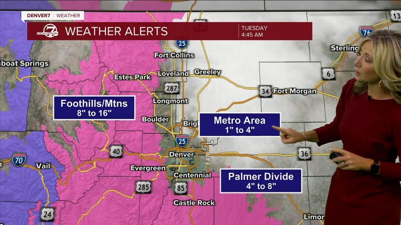
While the NWS said Tuesday afternoon that "the strongest storms [were] decreasing in intensity," it was still expecting 8-16 inches or more in those areas.
Several inches of snow had fallen in some parts of the high country by 10:30 p.m. Tuesday, according to NWS observations.
[4:37 PM Update] Radar shows the precipitation is increasing in coverage but the strongest storms are decreasing in intensity. We still expect most areas along the I-25 corridor will see 0.5-1" of rain with 8-16+" of snow in the mountains, foothills, and Palmer Divide. #COwx pic.twitter.com/JH3gRSIxJC
— NWS Boulder (@NWSBoulder) April 25, 2023
JeffCo Public Schools announced Tuesday night that its mountain schools would be closed Wednesday due to heavy snow in the forecast. Some shared bus routes would also be impacted, the district said, but non-mountain schools were going to remain open.
Along with the snow, locally heavy rain is possible along the I-25 Corridor which could lead to ponding on roadways, but fewer travel impacts are expected below 6,500 feet, the NWS said.
The heaviest snow totals are expected just west and south of Denver, according to Denver7 morning meteorologist Lisa Hidalgo.
“It’s an extremely fast-moving storm. The metro area will likely see around 1 to 4 inches of snow, with a lot of that being on the grass and on the rooftops early tomorrow morning when you wake up," Hidalgo said.
No accumulation is expected on paved surfaces in town.
On Tuesday afternoon, multiple thunderstorms rumbled around the state, bringing lightning, hail, rain and even a confirmed landspout tornado.
Hail covering I-76 near Keenesburg. Use caution if you plan to travel tonight. There may be slick spots with hail covering the road. Leave plenty of space between you and the car in front of you. #COwx pic.twitter.com/VQsLxqGxj9
— NWS Boulder (@NWSBoulder) April 25, 2023
A winter storm warning went into effect at noon Tuesday and will stay in place through noon Wednesday for the foothills and mountains where 1 to 2 feet of snow could fall, particularly at elevations higher than 8,000 feet. The Palmer Divide could see snow totals from 4 to 8 inches.

The NWS said snow could fall at a rate of up to 2.5 inches per hour in areas under the warning.
Heavy snow from 5 to 12 inches is also possible in Castle Rock, which is also under the winter storm warning.
For a full list of Colorado communities under the winter storm warning, click here.
TIMING
The heaviest snow will start to develop Tuesday afternoon in the mountains and foothills, the NWS forecasted. Heavier snow is expected to pick up in the evening and overnight hours in the Palmer Divide before slowing down by Wednesday morning.

Hidalgo said totals in the metro could be a little tricky to predict with this spring storm.
“A lot of the snow that we do see overnight will be melted off by tomorrow night’s commute," she said.
After this quick blast of winter weather and soaking rains, skies should rapidly clear out and sunshine should return by Wednesday afternoon in the Denver metro area.
Wednesday’s high temperature in Denver will be 55 degrees before sunshine returns on Thursday, when it will warm up to 63 degrees.
Another quick round of light rain and snow moves through Friday before a beautiful weekend arrives with sunny skies and high temperatures between the upper 60s and low 70s in Denver both Saturday and Sunday.
WHAT A TYPICAL APRIL IS LIKE IN COLORADO
The Denver7 360 In-Depth team charted an overall and detailed look at what to expect from the weather in April. The infographics tell the story of what to expect on a typical day as well as how much of a warm up to expect over the course of the month (according to the averages).

In this Denver7 360 In-Depth deep dive 📈
- Preview Denver's April weather 🌤
- Check the normal high/low by day ☀️
- Compare record low and high temperatures ☀️
- A look back at a rare April tornado outbreak in SE Colorado 🌪
- The wettest Aprils on record 🌧
To view April stats and data fullscreen on your computer or phone click here.
Denver7's Robert Garrison contributed to this report.

MORE: Closings and Delays | Latest forecast | Radars | Traffic | Weather Page | 24/7 Weather Stream
You can always watch 24/7 weather, radar and news updates on the free Denver7+ app on your TV.


