


For Sunday, a strong south-southwest wind will continue across the Front Range. An upper-level weather system moving in from California will reach our area by early Monday.
Storm activity is expected to be more widespread on Sunday afternoon. While storms will still be capable of producing strong winds, they will be a bit less intense than the storms for Saturday. Storms will move at around 20-25 miles per hour, which should help reduce the risk of flash flooding.
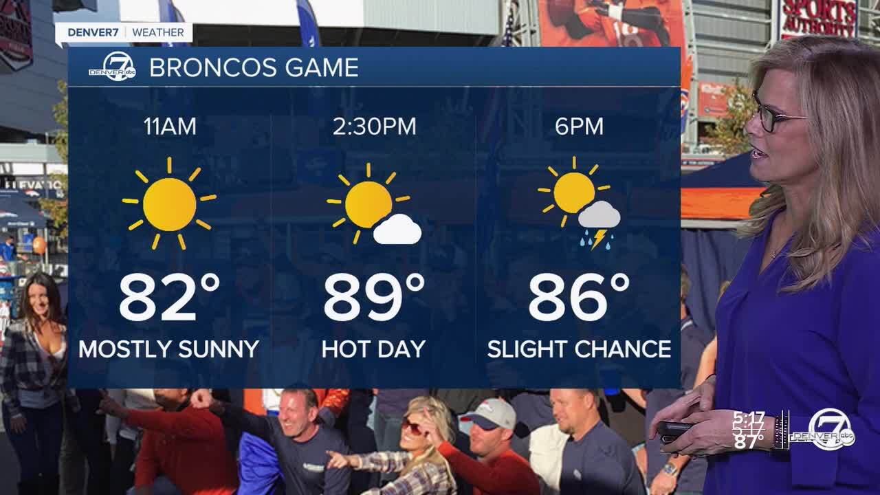
Temperatures on Sunday are expected to be slightly cooler, in the upper 80s to near 90 degrees. Be aware that a few isolated thunderstorms will be possible over Empower Field during the second half of the Broncos game Sunday afternoon.
Starting Sunday night, a weather system will bring showers to the Denver area. This system is expected to move through overnight and into Monday morning, with the best chance of rain happening during this time.
On Monday afternoon, as the system continues to move northeast, there will still be some lingering moisture, leading to scattered showers and possibly a few thunderstorms.
For Tuesday and Wednesday, the weather will shift as a drier air mass moves into northern Colorado. This will lead to warmer temperatures, making it feel hotter than usual for this time of year. Although the chances of rain are reduced, especially in the city, there might still be an isolated shower or thunderstorm, particularly in the mountain areas and along the Palmer Divide.
As we look ahead to Thursday, a cold front is expected to move southward across the northeast plains during the morning. This will bring cooler temperatures, with highs potentially dropping into the upper 70s or low 80s. While the cold front will bring a noticeable change in temperature, it is expected to move through dry, so significant rainfall is not anticipated. However, a few showers or thunderstorms could still occur near the Palmer Divide.
Friday and Saturday will bring a return to warmer conditions. High temperatures are expected to rise back to around normal or slightly above normal for this time of year. The weather will generally stay dry, with clear skies and minimal chances of precipitation. These days will be good for outdoor activities as the weather settles into a more typical late-summer pattern.
Looking further ahead, the overall trend suggests that the warm and dry conditions will continue into the weekend. With high pressure likely dominating, expect pleasant weather with temperatures that feel comfortable and no major storm systems on the horizon. This should make for a great end to the week, with plenty of sunshine and mild temperatures.
DENVER WEATHER LINKS: Hourly forecast | Radars | Traffic | Weather Page | 24/7 Weather Stream
Click here to watch the Denver7 live weather stream.
