


DENVER – Colorado's plains could see strong thunderstorms Thursday evening potentially dropping large hail and gusts up to 75 mph.
A severe thunderstorm watch has been issued until 11 p.m. for Cheyenne, Kit Carson, Lincoln, Washington and Yuma Counties.
The National Weather Service (NWS) in Boulder said isolated hail up to two inches in size is possible with severe storms that develop.
A cold front rolled through Colorado dropping high temperatures into the 80s and bringing scattered rain and storms in the Denver metro area.
A line of storms was pushing through Denver just in time for the afternoon commute.
Denver7 meteorologist Danielle Grant said showers will continue to push through the metro with a few lingering through the late evening hours.
“The risk of severe weather has now gone up,” said Denver7 Meteorologist Lisa Hidalgo. “The risk level goes up as you head farther east with larger hail and damaging winds being two of the biggest issues.”
Hidalgo added there could be areas of heavier rain as “we tap back into that monsoon moisture.”
The National Weather Service (NWS) in Boulder said eastern Colorado is under a marginal to slight risk of severe storms as “large hail and strong gusty winds will be the main threat with these storms.”

While Denver is expected to see scattered afternoon and evening thunderstorms – a few of which could turn strong to severe – Sterling, Fort Morgan, Castle Rock to Colorado Springs are under the marginal risk of severe storms.
Limon, Akron to Flagler and Wray are under a slightly higher risk of severe weather.
The evening commute in Denver could be stormy in some areas.
“Scattered showers and storms are likely today and you’re going to see some wet roads for tonight’s commute,” added Hidalgo. “We could see some localized flooding, including in the burn scar areas as we get some slower-moving cells bringing heavier pockets of rain.”
The NWS said the threat of tornadoes is low as is the hail threat with storms not expected to be widespread across the state.
“Today should feature a higher chance of rain across most of the forecast area, but there are lots of factors that could once again keep your backyard dry today,” said NWS forecasters early Thursday.
The cold front will break Denver’s streak of 90-degree heat with Friday’s high temp expected to be in the upper 80s – which are seasonal norms – before 90s return for the weekend.
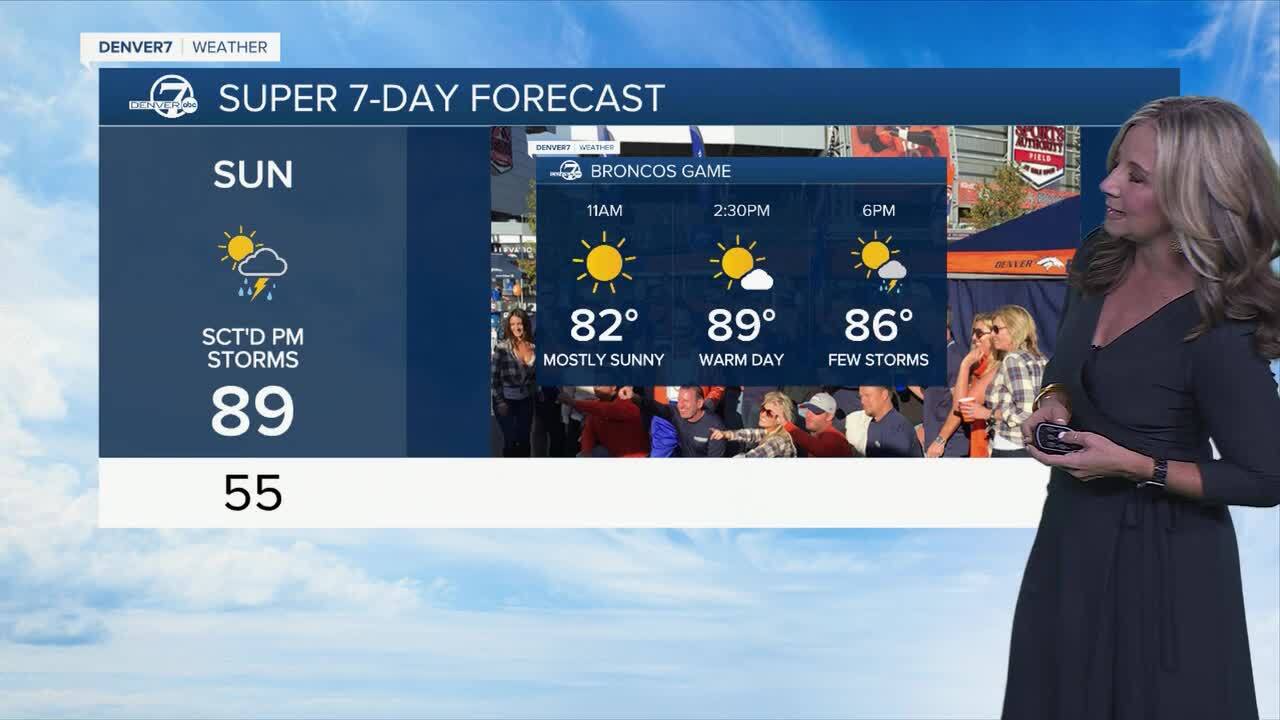
Saturday in Denver the high temperature is expected to warm to 92 degrees with isolated storms. On Sunday, a slightly better chance of storms arrives in Denver with the high temperature reaching 89 degrees.
By the 2:30 p.m. kickoff between the Broncos and Cardinals at Empower Field, fans should expect partly cloudy conditions with a chance of a few storms by the end of the game.

Denver’s 10-day forecast
- Thu: 84° | PM storms likely
- Fri: 88° | Scattered storms
- Sat: 92° | Isolated storms
- Sun: 89° | Scattered PM storms
- Mon 83° | Partly cloudy
- Tue 90° | Mostly sunny
- Wed 92° | Scattered PM storms
- Thu 80° | Mostly sunny
- Fri: 86° | Mostly sunny
DENVER WEATHER LINKS: Hourly forecast | Radars | Traffic | Weather Page | 24/7 Weather Stream
Click here to watch the Denver7 live weather stream.