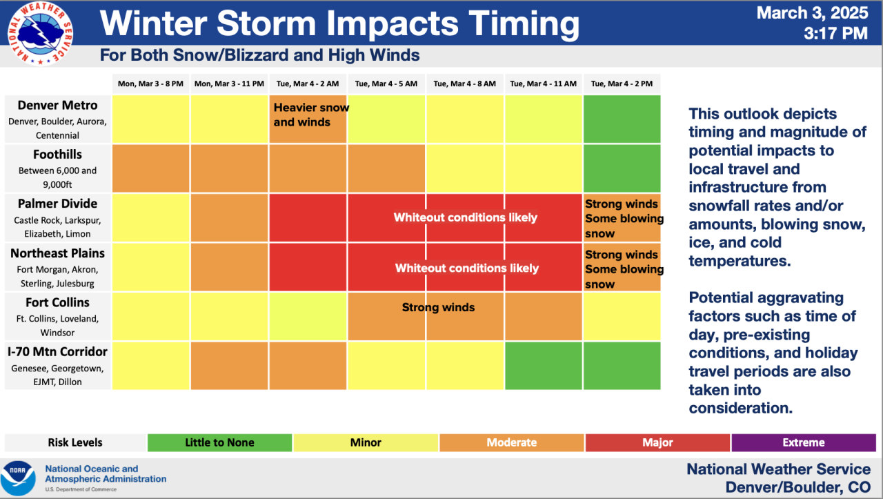
DENVER – Colorado’s weather whiplash will bring potential blizzard conditions to the eastern plains, the Palmer Divide with heavy snow in the mountains as wet, slushy snow is expected in the Denver metro area over the next 24 hours.
It’ll be quite the change Tuesday from the last few days of above average temps and sunny skies.After Monday’s high temp warms into the 60s in Denver, conditions will start to change later in the day.
“We're expecting snow in through the Northern Front Range mountains by this afternoon, a few showers – even a few thunderstorms are possible across the eastern plains this afternoon – so we may see some wet roads for the evening commute, especially north near Longmont, Fort Collins and Greeley,” said Denver7 chief meteorologist Lisa Hidalgo.
“Here in town a little closer to Denver, we'll see some of that rain start to fill in late afternoon, early evening, that is going to then switch over to all snow overnight tonight.”

A slew of winter weather alerts are in place for the state, including a blizzard warning for portions of Elbert, Lincoln and Washington Counties starting at 11 p.m. Monday through at least 5 p.m. Tuesday, according to the National Weather Service (NWS) in Boulder.
“Blizzard conditions are expected. Total snow accumulations between 2 and 8 inches. Winds gusting as high as 65 mph,” wrote NWS forecasters.
Matheson, Akron, Limon, Agate, Huge, Last Chance and Otis are included in the blizzard warning. The NWS added there is uncertainty on the storm track and locations of potential heavy bands of snow in the area.

Closer to the Denver metro, a blizzard warning will go into from midnight tonight through 2 p.m. Tuesday for portions of Elbert and Douglas Counties, including Castle Rock, where between 4 and 10 inches of snow or more is possible with wind gusts up to 60 mph, wrote the NWS.
This alert was upgraded from a previous winter storm warning.
“In spots, we're expecting some heavy snow, potentially a few bands of snow, that would leave us with snowfall rates of upwards of around one to two inches per hour,” added Hidalgo. “Heaviest snow is likely going to be southwest and east of Denver and across the far eastern plains. The winds will kick up, and we're also expecting some blizzard-like conditions.”
Check latest winter weather alerts in Colorado
Colorado’s Front Range Mountains will also go under a winter storm warning Monday afternoon for heavy snow and accumulations up to 14 inches.

The storm system will quickly clear out. After Tuesday’s blast of winter, Denver’s high temp on Wednesday warms into the 50s with mostly sunny skies. The warming trend continues through Thursday before another quick blast of snow is possible Friday morning.
As for Tuesday’s winter storm, the main areas of concern look to be conditions on the plains, the high country and Palmer Divide.
“In the metro area tomorrow – likely south of Denver and closer to Highlands Ranch, through Castle Pines, Castle Rock, Larkspur and south of there – is where we’re going to see upwards of 5 to 10 inches of snow and really gusty winds. So blizzard-like conditions are expected.

Likely Denver metro, Colorado snow totals from the NWS
- Downtown Denver: Less than 1”
- Denver International Airport: Less than 1”
- Byers: 2”
- Boulder: Less than 1”
- Georgetown: 8”
- Castle Rock: 6”
- Kiowa: 6”
- Winter Park: 14”
- Walden: 4”
- Lakewood: Less than 1”
- Fort Collins: Less than 1”
- Limon: 6”
- Sterling: 1”
- Fort Morgan: Less than 1”
- Fairplay: 3”
- Holyoke: 4”
- Julesburg: 3”
- Breckenridge: 5”
- Vail Pass: 12”
You can check potential low-end and high-end totals from the NWS by clicking this link.
Denver7 is tracking how this snow season compares to previous years. Check Colorado snow statistics in the graphic below or in fullscreen mode by clicking this link.

DENVER WEATHER LINKS: Hourly forecast | Radars | Traffic | Weather Page | 24/7 Weather Stream
Click here to watch the Denver7 live weather stream.


