

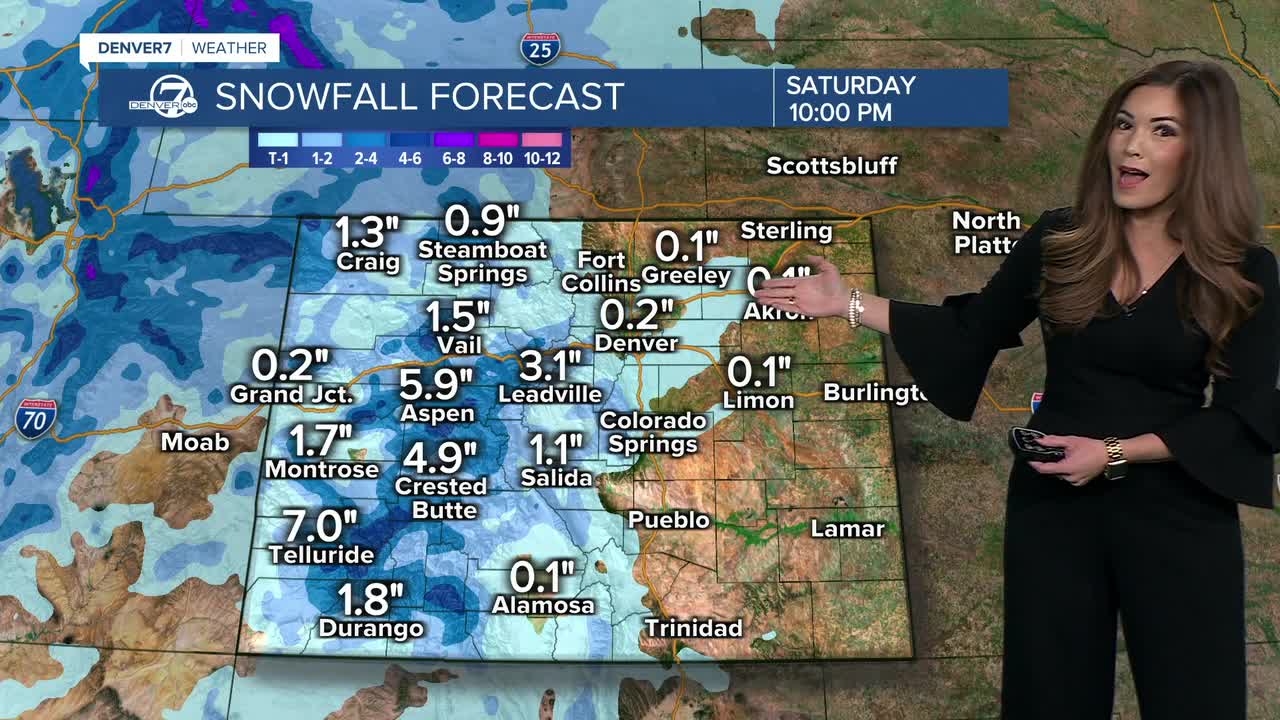


DENVER — It'll be a mostly clear and breezy night along the Front Range as a quick-moving system moves across the state. It'll usher in scattered snow showers overnight into early Friday, especially across the Park Range and Elkhead Mountains.
Strong winds will be the big weather story across Colorado on Friday, with gusts reaching 50 mph on the plains and up to 65 mph in the mountains. A powerful jet stream overhead will help push those winds down by late morning, with the strongest gusts expected through the afternoon.
Most of the plains, including the Denver metro area, could see gusts between 30 and 50 mph. The northern I-25 corridor and parts of the northern plains should stay a bit more sheltered for much of the day. That changes late Friday afternoon as a cold front approaches from the north, shifting winds more to the west and northwest. Gusts of 25 to 40 mph will become possible in areas that had been more protected.
The combination of strong winds and relatively dry conditions will bring elevated fire weather concerns Friday afternoon. However, humidity levels are expected to stay above critical thresholds, so widespread critical fire weather conditions are not anticipated.
With the strong downsloping winds, temperatures will warm into the low 60s ahead of the evening cold front. That front will bring a noticeable cool down and it could also squeeze out a few snow showers overnight Friday into Saturday morning. A combination of the approaching weather system and some upslope flow could produce light snow in the mountains and even a few showers across the plains. Moisture will be limited, though, keeping accumulations on the light side. Most mountain areas could pick up an inch to 3 inches of snow, with the Park Range favored for slightly higher totals.
For the Denver metro area, the chance of seeing even a trace of snow remains low at around 20 percent or less. Temperatures Saturday morning will be cold enough for rain to mix with snow or even fall as all snow, but the lack of moisture and stronger lift will keep the odds of meaningful accumulation very low.
Colder weather sticks around into next week, with overnight lows dropping into the teens and 20s Sunday through Wednesday. Another system approaches Monday, bringing a chance for light mountain snow late Monday into Tuesday. There is also a chance that a few snow showers reach the plains, but any accumulation is expected to be light.
The pattern looks more active heading into the second half of next week, but forecast models are still all over the place on timing and potential impacts. We'll be watching your Thanksgiving forecast as it gets closer.
DENVER WEATHER LINKS: Hourly forecast | Radars | Traffic | Weather Page | 24/7 Weather Stream
Click here to watch the Denver7 live weather stream.
Denver7 live 24/7 weather stream
DENVER WEATHER LINKS: Hourly forecast | Radars | Traffic | Weather Page | 24/7 Weather Stream
Click here to watch the Denver7 live weather stream.
