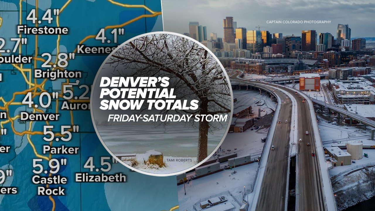
DENVER — Denver’s weather forecast shows potential snow totals ranging from 2 to 6 inches or more for the next big weather maker blowing through the metro starting Friday through the day Saturday, according to the latest weather models, but there remains uncertainty as to how much snow will fall in the metro.
Denver's potential snow fall predictions continued to change on Thursday with Denver7 Chief Meteorologist Mike Nelson estimating between 3 to 6 inches of snow for the lower elevations along the Front Range.
"A pretty decent little snow maker," said Nelson. "Over the weekend cold and next week a little bit milder."
Denver, along with the entire metro area and communities north through Fort Collins will go under a winter storm watch Friday afternoon through Saturday night, according to the National Weather Service (NWS) in Boulder.
"Heavy snow possible. Total snow accumulations between 4 and 8 inches with locally higher amounts up to 12 inches possible. This includes the Front Range Foothills, Palmer Divide, Urban Corridor and adjacent plains," said the NWS in the weather alert.
The winter storm watch includes Golden, Boulder, Aurora, Castle Rock, Estes Park, Longmont, Denver, Lakewood, Fort Collins, Highlands Ranch, Arvada, Brighton, Parker among other communities.
“Those snow totals are still pretty variable and it looks like those latest models have pushed up those snowfall totals here in the last 24 hours,” said Denver7 Meteorologist Stacey Donaldson. “We do have chances for some rain and snow as we head into the overnight tonight and that will affect us for our Friday morning.”

Light snow should arrive in Denver in the morning and then again Friday night into Saturday, said Donaldson.
“That snowfall pushes across the eastern plains as we get into Friday night and then into Saturday it just kind of spreads out all across eastern Colorado.”
Donaldson said right now the models show Denver snow totals could range from between 2 to 6 inches with pockets of accumulation up to 8 inches along some areas of the Front Range and I-25 corridor.
Colorado’s mountains will see moderate snow Thursday as several winter weather alerts are in place through the day, according to the National Weather Service (NWS) in Boulder.
A winter storm warning is in effect through 5 p.m Thursday for portions of Jackson and Grand Counties at elevations above 9,000 feet.
The NWS said high winds and additional snow accumulations up to 2 inches are possible at Rabbit Ears Pass.
Check latest Colorado winter weather alerts at this link.
A winter weather advisory is also in effect through late Thursday afternoon for parts of Jackson, Larimer and Boulder Counties above 9,000 feet for winds up to 50 mph and 2 inches of additional snowfall, according to the NWS.
Meteorologists stressed uncertainties around the winter storm’s track are impacting Denver’s potential snow totals and potential accumulations in communities along I-25.
The storm “could bring accumulating snow to the Foothills, I-25 corridor, and portions of the plains late Friday through early Sunday, but details remain fairly uncertain at this time,” said the NWS in its Thursday morning update.

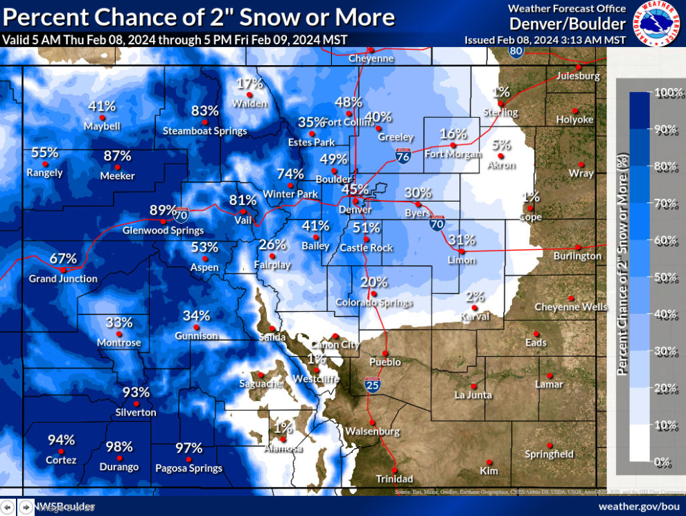
The NWS’ snowfall prediction tool, which currently shows the forecast from Thursday through Friday afternoon showed a wide range of potential snow totals across Colorado.
It’s important to note the below snowfall predictions do not yet include the remainder of the storm timeline through Friday night and Saturday.
By Friday at 5 p.m., Denver has a 45 percent chance of seeing 2 inches or more of snow. Castle Rock shows a 51 percent chance of seeing 2 inches or more of accumulation.

Boulder and Fort Collins have a 49 percent chance of receiving 2 inches or more of snow by late Friday afternoon.
Again, the NWS predictions are currently just through Friday at 5 p.m.
“That snowfall pushes across the eastern plains as we get into Friday night and then into Saturday it just kind of spreads out all across eastern Colorado,” said Donaldson. “We’re going to see snowfall sticking around for much of the day even as we get toward 3 to 4 o’clock.”
To view the Denver snowfall statistics infographics in fullscreen mode click this link.
The snow in Denver on Friday and this weekend will help the metro reach the normal totals for February. The NWS reporting station at Denver International Airport shows Denver has already received 5.5 inches of snow compared to the monthly normal of 7.8 inches.
For the 2023-24 season, Denver’s snow totals are around 14 inches behind the normal cumulative total. So far, 20.9 inches of snow has fallen at Denver’s official reporting station compared to the 34.9 inches we’d normally see by this time of the season.
Snow finally clears out of Denver by the later part of the weekend. Sunday’s high temperature in the metro should reach the low 40s with partly cloudy skies. Denver’s weather forecast for the first half of next week shows more sunshine and highs warming into the low to mid 40s.

WEATHER LINKS: Closings and Delays | Latest forecast | Radars | Traffic | Weather Page | 24/7 Weather Stream
You can always watch 24/7 weather, radar and news updates on the free Denver7+ app on your TV.
Click here to watch the Denver7 live weather stream.


