DENVER — Colorado’s next storm system is on track to potentially bring heavy snow into the western suburbs of Denver and communities north, including Boulder and Fort Collins throughout the day Wednesday.
New to the forecast is a wind chill advisorythat includes the Denver metro, Boulder, Fort Collins, Greeley and the northeastern plains. Motorists should be prepared for snow-covered roads Wednesday the possibility of a flash freeze, or wet roadways that can quickly freeze and make travel difficult.
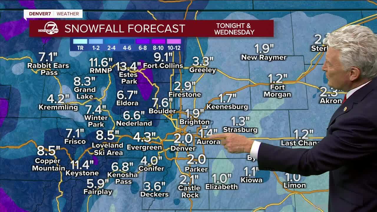
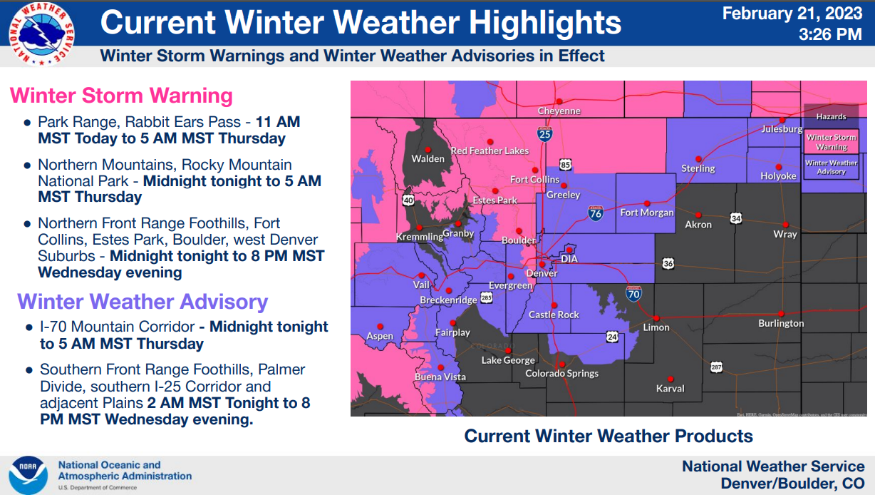
A winter storm warning for the area is in effect through 8 p.m. Wednesday and could bring 4 to 8 inches of snow, according to the National Weather Service in Boulder.
On Wednesday morning, the NWS said snow should increase through the morning on top of what has already fallen overnight along the foothills and I-25 corridor but there is some uncertainty on heavier snow totals.
Fort Collins, Lakewood, Golden, Longmont, Arvada are included in the winter storm warning.
Denver, Castle Rock, Greeley, Fort Morgan and communities along and east of the I-70 corridor are under a winter weather advisorywith 3 to 6 inches of snow possible, the NWS said.
Denver and these communities will stay under the winter weather advisory through 8 p.m. Wednesday.

LATEST TIMING
This storm system began bringing snow in the northern mountains Tuesday afternoon making driving conditions difficult in Colorado’s high country, the NWS said.
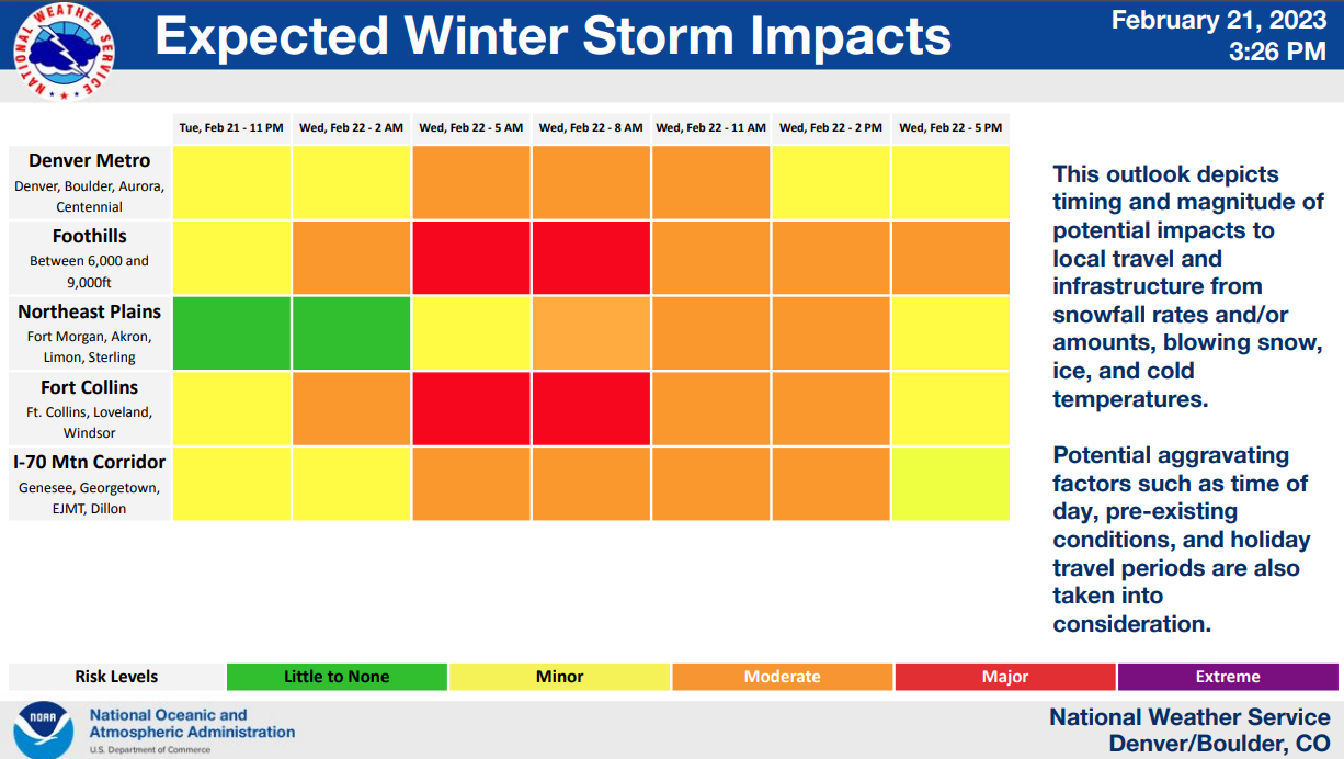
Slippery road conditions should be expected all day Wednesday, including the afternoon commute in the Denver metro area and all along the warning and advisory areas.
“We could be waking up early tomorrow for the commute with around 1 to 2 inches of snow on the ground with more to come.” said Lisa Hidalgo, Denver7 morning meteorologist.


Denver7 | Weather
Why does it always seem to snow on Wednesdays? We asked the NWS
A Denver7 weather action day is in effect to update you on the latest conditions and help you prepare for the storm.
Wednesday’s high temperatures will happen around midnight with conditions turning colder throughout the day. Expect temps in the teens during Wednesday afternoon and skies will gradually clear out Wednesday night and early Thursday morning.
The wind chill advisory for Denver and surrounding communities is in effect Wednesday through 9 a.m. Thursday. The NWS said wind chills could drop as low as 25 degrees below zero and wind gusts up to 45 mph. Fort Collins, Greeley and the northeast plains will go under the wind chill advisory at 8 p.m. Wednesday.
Thursday’s high temperature will be around 27 degrees in Denver and a gradual warm up begins with sunshine and high temps in the low 50s through the weekend.

MORE POTENTIAL SNOW TOTALS
Rocky Mountain National Park and Medicine Bow Range could see heavy snow and accumulations from 8 to 16 inches, according to the NWS. This area will be under a winter storm warning Wednesday night through 5 a.m. Thursday.
Heavy snow is possible in the foothills and northern parts of the I-25 corridor, including Park Range and Larimer county foothills, the NWS warns.
Fort Collins, Nederland, Estes Park, Loveland and Raymer are among the communities that could see 4 to 8 inches of snow.

The winter storm warning is now in effect in West Jackson and West Grand Counties. In elevations above 9,000 feet heavy snow is expected, between 12 and 24 inches, the NWS said.
2022-2023 SNOWFALL SEASON
So far, Denver has seen 40.5 inches of snow for the 2022-2023 season. Another 3 to 6 inches will add to snow metro totals, according to Lisa Hidalgo. This next storm system will only add to what has been an above average snowfall for Denver.
Stay with Denver7 for updates to potential snow totals and timing on the storm. We will publish a live blog on Wednesday morning to track road closures, potential school delays and storm updates.
To view the above weather infographic in full-screen mode, you can click here.

MORE: Closings and Delays | Latest forecast | Radars | Traffic | Weather Page | 24/7 Weather Stream
You can always watch 24/7 weather, radar and news updates on the free Denver7+ app on your TV.


