


DENVER — It's a Denver7 Weather Action Day as the Front Range braces for a significant late spring snowstorm in the forecast late Tuesday into Wednesday.
The storm is expected to peak late Tuesday evening into Wednesday morning. The main concern for the Denver metro area is downed tree limbs that could lead to scattered power outages due to the wet, heavy snow expected to fall starting mid to late Tuesday evening — so be sure to shake your trees off before you go to bed!
Roads will likely become slick and slushy, especially during the Wednesday morning commute, so make sure to give yourself extra time before heading to work Wednesday.
We're tracking the latest updates on the forecast, traffic and impacts from the storm in the blog below.

LINKS: Closings and Delays | Latest forecast | Radars | Traffic | Weather Page | 24/7 Weather Stream
Wednesday, May 6
11:01 a.m. | Denver Zoo closed | The Denver Zoo Conservation Alliance will remain closed Wednesday as snow continues to fall across the Denver metro.
Update as of May 6 at 11a.m.: Due to continued snowfall, DZCA will remain closed for the duration of the day on Wednesday, May 6. https://t.co/Ut12UoDa51
— Denver Zoo Conservation Alliance (@DenverZoo) May 6, 2026
10:08 a.m. | Boulder off crash alert | The City of Boulder is no longer on a crash alert following Tuesday night's snowstorm.
10 a.m. | Weather update | The Denver metro area has averaged between 4 and 10 inches of snow from Tuesday night's snowstorm with the highest totals located on the south and west sides of the metro, according to meteorologists with the National Weather Service in Boulder.
9:04 a.m. | Trees down in Loveland | Officials in Loveland are reporting downed trees across the city, which has caused branches to fall on power lines. City officials are urging people to stay back and call 911 if they spot a downed power line.
8:57 a.m. | Xcel power line repairs | Xcel Energy said some customers saw 12 inches of snow or more overnight, causing approximately 55,000 customers to lose power. The utility said has crews working to restore power. Xcel shared the following picture of some of the snow accumulated on power lines.
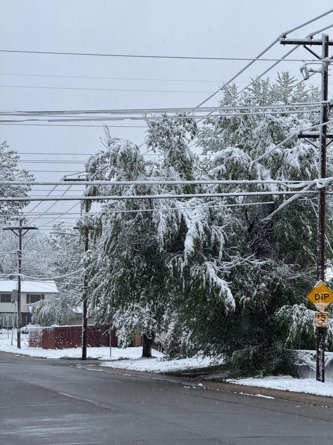
8:49 a.m. | Broomfield fallen trees | There are lots of fallen and broken tree branches across Broomfield, according to the police department.
Broomfield PD shared a picture of Midway Park and advised residents to look up while walking or heading out to your car.

7:40 a.m. | Arvada delayed start | Due to power outage at City Hall, the City of Arvada said facilities will delay opening until 10 a.m.
7:38 a.m. | Xcel Energy outages | There are 28,166 Xcel Energy customers across the Front Range without power, according to the utility's outage map.
6:58 a.m. | Boulder County closure | The Boulder County government offices were put on a snow delay. They won't open until 10 a.m.
6:26 a.m. | RTD delays | The Regional Transportation District advised travelers to anticipate potential delays due to the snow.
4:12 a.m. | Check of metro roads | From Denver7 Traffic Expert Jayson Luber: "The main highways are mostly just wet with some slush here and there. But let me say, there is a lot of water out there and that is a major concern at higher speeds."

4:05 a.m. | Arapahoe County delay | County offices will be on a delayed start, opening at 10 a.m. Wednesday.
3:55 a.m. | Snow forecast for this AM | The NWS said the heaviest of snow will linger in the Denver metro through the morning hours before gradually tapering off this afternoon. The winter storm warning remains in effect until 3 p.m.
A freeze warning goes into effect for the eastern plains tonight through Thursday morning.

3:35 a.m. | Latest closings/delays | Over 120 closings and delays have been reported for Wednesday impacting schools, universities, nonprofits and local government.
Here's the complete list.
Tuesday, May 5
9:57 p.m. | 🚨 Boulder on crash alert | The city of Boulder is on crash alert due to limited resources. A crash or accident alert means that police will not respond to minor or non‑injury crashes. Drivers should exchange information and self‑report the crash later.
9:16 p.m. | 🚸 Adams 14 Schools closed | Adams 14 Schools announced it will be closed Wednesday due to inclement weather conditions. All activities, athletics, and after school programs are canceled unless otherwise communicated, the district said. Full list of closures and delays
9:15 p.m. | 🚸 Littleton Public Schools closed | Littleton Public Schools announced it will be closed Wednesday due to inclement weather conditions. Full list of closures and delays
8:45 p.m. | 🚸 JeffCo Public Schools closed | JeffCo Public Schools announced it will be closed Wednesday due to inclement weather conditions. Full list of closures and delays
8:42 p.m. | ✈️ DIA delays | Flight Aware reported more than 500 delays at Denver International Airport Tuesday as the Front Range deals with a strong, late-season snowstorm that moved in.
8:41 p.m. | 🚸 Boulder Valley Schools closed | The Boulder Valley School District announced it will be closed Wednesday due to inclement weather conditions. Full list of closures and delays
8:14 p.m. | 🏛️ Denver city government delayed opening | City and County of Denver government agencies will be operating on a two-hour delay in scheduled start times for city employees reporting for work on-site on Wednesday due to inclement weather, the city announced. Full list of closures and delays
8:11 p.m. | 🚸 CSU closed | Colorado State University announced it will be closed Wednesday. All in-person, hybrid and remote classes and operations (meetings, work functions) are closed or canceled for all Larimer County campuses, CSU said. Full list of closures and delays
8:06 p.m. | 🚸 DCSD closed | The Douglas County School District announced it will be closed Wednesday due to inclement weather conditions. Full list of closures and delays
7:39 p.m. | 🚸 CU Boulder closed | CU Boulder said its campus will be closed Wednesday due to a winter storm, warning staff and students to watch for falling branches and outages. Full list of closures and delays
7:28 p.m. | 🚸 DPS closed | The state’s largest district, Denver Public Schools, joined other major districts and canceled Wednesday classes due to severe weather. This closure includes the Emily Griffith Technical College and all school-related events and activities, the district said. Full list of closures and delays
7:14 p.m. | 🚸 Weld RE-4 closed | Due to weather conditions, Weld RE-4 announced all schools will be closed Wednesday. Full list of closures and delays
7:05 p.m. | 🚸 APD closed | Due to weather conditions, Aurora Public Schools and Pickens Technical College announced all schools will be closed Wednesday. The district advises staff and students to stay home for safety reasons. Full list of closures and delays
5:30 p.m. | Heavy snow begins to fall in Denver| Snow has begun to fall across Denver, and more flakes are to come through the rest of the day and into the overnight hours.
The NWS is forecasting 5-8 inches of snow for the I-25 Corridor by Wednesday afternoon, while areas closer to the foothills could receive up to 9 inches.
A stretch from about Tuesday midnight to 9 a.m. Wednesday should have the biggest impact for the Denver metro, according to the NWS.

Denver7 | Weather
Denver area faces hazardous morning commute as heavy snow moves in
Wet, heavy snowfall poses the greatest risk for broken branches and tree damage, especially in areas with the largest accumulations, which could cause scattered power outages.
Hazardous conditions, especially for the morning commute in the Denver metro area, are expected due to heavy snowfall. The Colorado Department of Transportation and the City of Denver are prepared for those impacts.
Read the latest forecast here.
4:46 p.m. | Elbert County delays | All Elbert County government offices will be on a two-hour delayed schedule Wednesday, May 6, county officials said via social media Tuesday.
4:33 p.m. | Denver weather update | The City of Denver says its snow plow drivers are on duty and will be monitoring the main streets. Given the heavy, wet snow expected in the area, city officials provided the following tips for residents:
Removing Snow from Trees:
- Make sure the tree is safe and clear of utility lines; for safety reasons, residents are only encouraged to remove snow from small, young trees (planted within the last five years). Removing snow from larger trees can be dangerous due to falling debris.
- Only use the bristle side of a broom to gently brush off the snow. Do not hit the tree; any physical contact with the branches can cause more damage.
- Residents can also gently shake the trees to remove the snow, while watching for falling snow and staying safe.
- Keep checking the trees. Once snow stops, heavy snow from the top of the tree can fall to lower branches and overload lower limbs causing damage.
Downed branches:
- Property owners are responsible for pruning and cleaning up all debris from trees located on private property and within the public right of way adjacent to their property.
- Residents can visit www.denvergov.org/forestry for a list of licensed and insured tree care contractors.
- If emergency removal of a fallen tree or tree branch is needed immediately to clear a street, the city will remove it; the cost of the work will be billed to the responsible property owner.
- If safe, residents are asked to remove any obstructions to the public street, right of way, and sidewalk. Also, avoid parking underneath trees.
Disposal of Tree Branches:
- Residents have a few options for disposing of downed branches. Branches must be no larger than 4 inches in diameter and cut into lengths of 4 feet or less.
- Denver Solid Waste Management customers can dispose of branches that fit inside their compost cart.
- Solid Waste Management also collects a limited amount of branches as part of its Large Item Pickup service. Branches must be bundled and tied and weigh no more than 50 pounds. Customers may set out up to 10 bundles of branches on their scheduled Large Item Pickup day.
- Residents may also dispose of branches at the Cherry Creek Recycling Drop-off [denvergov.org] at 7400 Cherry Creek S. Drive during regular operating hours. Again, branches must be no larger than 4 inches in diameter and cut into lengths of 4 feet or less.
4:23 p.m. | Littleton delays | All City of Littleton facilities, including Littleton Center, Bemis Public Library, the Littleton Museum, and Littleton Municipal Court will open at 10 a.m. on Wednesday, May 6, city officials announced Tuesday.
4:06 p.m. | Closings | The Oval on CSU's Main Campus will close at 6 p.m. due to wet, heavy snow on tree branches. Barricades will be placed, and the area will remain closed tomorrow, university officials announced via social media. Students are advised to avoid entering the Oval area and follow all posted signs and barricades.
3:45 p.m. | Weather update | On-and-off rain showers continue for the Denver metro, but that's about to change in a few hours when a storm system moving from the north arrives to our area, bringing potentially between 4-5 inches of fresh powder by Wednesday afternoon, according to meteorologists from the National Weather Service.
During a briefing earlier Tuesday, Kenley Bonner, a meteorologist for the NWS office in Boulder, told news media the main concern from this storm is the heavy, wet snow that could lead to downed tree limbs and scattered power outages across the Front Range.
She said that while the northern mountains in Boulder and Larimer counties will encounter difficult travel conditions, some uncertainty still remained on the impacts to the roadways along the I-25 Corridor and other lower elevations.
Check out the latest timing for heaviest snowfall across Colorado in the table below:

Bonner said a freeze warning will also be in effect for a period of about 12 hours starting at 8 p.m. Wednesday for all of the plains and the I-25 Corridor in northeast and east central Colorado.
12:29 p.m. | School closures | Classes are canceled at Red Feather Lakes Elementary, Stove Prairie Elementary, and Livermore Elementary as wintry conditions "may make it unsafe to provide student transportation on mountain routes," officials with the Poudre School District said in a letter to parents and staff earlier Tuesday.
10:50 a.m. | Cold weather shelters | The City and County of Denver announced shelters would be available beginning, Tuesday at 6 p.m. through Thursday at 11 a.m. in preparation for the incoming snowstorm and cold weather.
They include:
- Denver Rescue Mission Lawrence Street Community Center at 2222 Lawrence Street for men.
- Samaritan House Smith Road at 6240 Smith Road for women.
- Urban Peak at 1630 S. Acoma Street for minors and young adults between 12 and 24 years old.
- Inn at the Highland at 2601 Zuni Street for families.
10:15 a.m. | Rockies game rescheduled | The Colorado Rockies said the team's game against the New York Mets was postponed to Thursday at 1:10 p.m. It was originally scheduled for Tuesday at 6:40 p.m.
The start time for Wednesday's game will be pushed back from 1:10 p.m. to 7:20 p.m. that same day.
Fans who purchased tickets for either game will be notified via email.
4:30 a.m. | Morning forecast | The Denver metro area is expecting between 4 and 8 inches of snow south of the I-70 mountain corridor and up to 12 inches possible near the foothills and across the Palmer Divide late Tuesday into early Wednesday.
A winter storm warning is in effect from 8 p.m. Tuesday to 3 p.m. Wednesday for Denver, Boulder, Fort Collins, Castle Rock and surrounding areas, including the western suburbs.
- Watch the full forecast in the video player below.
Monday, May 4
9:11 p.m. | Red Rocks concert cancellation | Red Rocks Ampitheatre announced the Bright Eyes concert originally scheduled for Wednesday, May 6, will be postponed until Tuesday, May 12.
The concert venue said it will honor previously purchased tickets for the new date.
"May 12 was the only available option this year. It may not be ideal, but we’d much rather get to play this incredible venue a few days later than cancel outright. If you can’t make it next week, you will be missed," Bright Eyes said on Facebook.
4:30 p.m. | Avs Alley closed for Tuesday's game | The outdoor fan viewing area that Ball Arena set up to for the Colorado Avalanche Stanley Cup Playoffs games will be closed for Tuesday's Game 2 against the Minnesota Wild, Kroenke Sports & Entertainment said. The franchise owners said the decision was made due to the forecasted inclement weather to ensure the safety of everyone involved.
Click here to watch the Denver7 live weather stream.
Editor's note: A previous version of this story included information about a high wind warning that was issued earlier this month. That information has been removed.