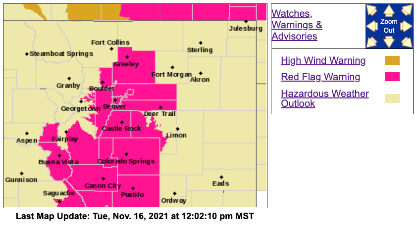
Multiple red flag warnings across the Front Range and southern Colorado warn that conditions are ideal for a fire to spark and quickly spread Tuesday.
The warning is in effect until 5 p.m. Tuesday for much of the Front Range, including the urban corridor, nearby plains, southern foothills and South Park, according to the National Weather Service (NWS).
Gusts have reached 35 to 45 mph with low humidity. The NWS said some Front Range mountains could see gusts up to 65 mph Tuesday afternoon.

A Red Flag warning isn't in effect for Larimer County, but officials there are currently working to put out a blaze near Estes Park that has spread quickly thanks to similar conditions. As of 9:45 a.m., the fire, called the Kruger Rock Fire, was 75 acres. The wind at the blaze is between 25 and 30 mph, but gusts will grow stronger this afternoon, according to NWS.
The warning is in effect for the following counties and areas:
- Central, northeast and southeast Park County
- Jefferson County
- Gilpin County below 9,000 feet
- Clear Creek County below 9,000 feet
- Boulder County below 6,000 feet
- West and east Broomfield County
- Douglas County
- Denver County
- Central, east, and west Adams County
- Arapahoe County
- Elbert County
- Central and south Weld County
- Upper Arkansas River Valley
- Fremont County
- Teller County
- Southern mountains (including Sangre De Cristo Mountains, Wet Mountains, and La Veta Pass)
- San Luis Valley
The Red Flag Warnings will end at 5 p.m. as a cold front moves across the state.
On Tuesday night, light snow is possible over the mountains. Residents will see a chillier Wednesday before more mild temperatures move in, according to the NWS.
The cold front will keep the Front Range and plains cold, but won't bring much, if any, precipitation.
The NWS said there is no "significant rain or snow in sight" for the plains. Denver’s snow-free fall so far is closing in on breaking records for the latest first measurable snowfall of the season. The latest-ever first snow in Denver fell on Nov. 21, 1934.


