DENVER – Colorado’s snowpack improved in most river basins after last week’s snowstorm, and areas of eastern Colorado have slightly less drought after the rain and snow that fell across the area, according to the latest data on Thursday.
Statewide, the snowpack was at 71% of median levels compared to the 1991-2020 period on Thursday. That’s up from 64% of median levels it sat at two weeks ago across all eight river basins.
Two of the basins – the Arkansas and Upper Rio Grande – saw good boosts to their snowpack from last week’s storm.

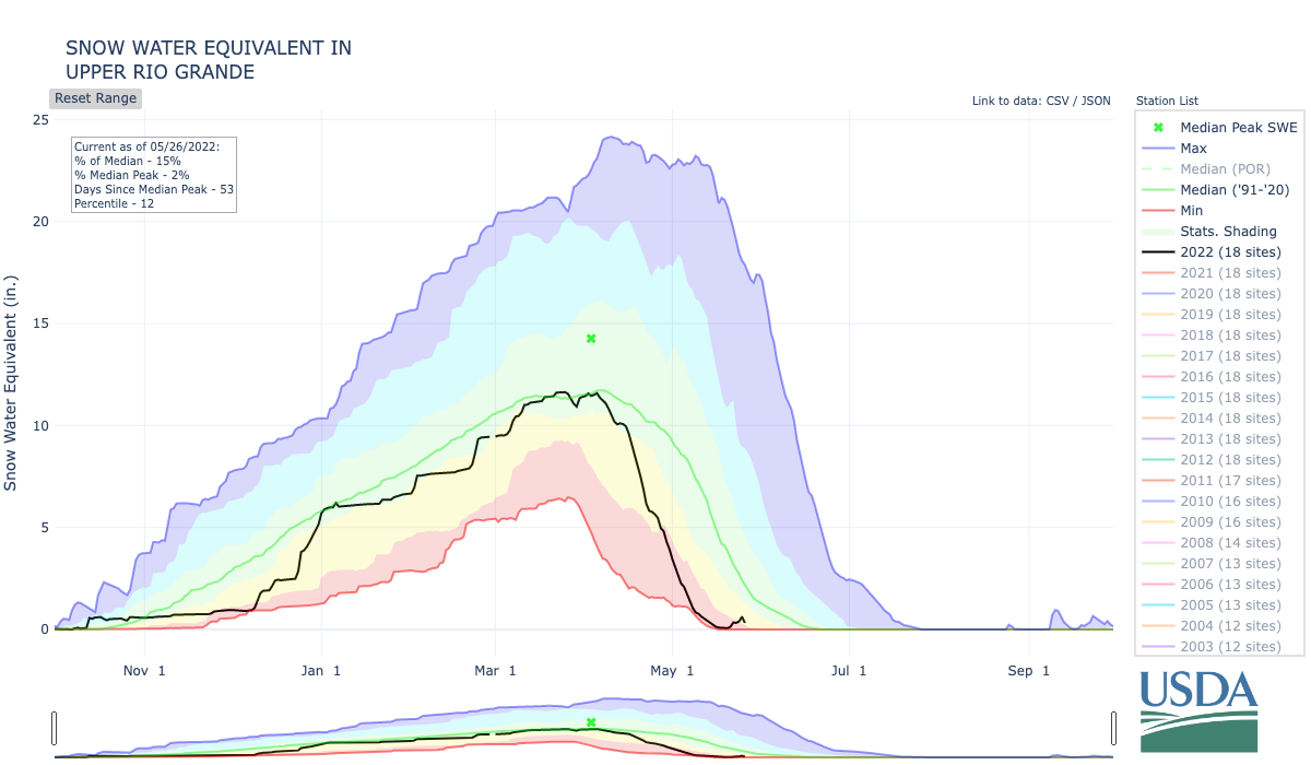
The Upper Rio Grande was back up to 15% of median levels Thursday, at 0.6 inches of snow water equivalent, after the snowpack almost disappeared last week. It bottomed out at 0.1 inches of snow-water equivalent mid-week last week before the storm.
And the Arkansas basin was at 88% of median levels Thursday – up from 35% of median as of May 12, now sitting at 2.3 inches of snow-water equivalent.
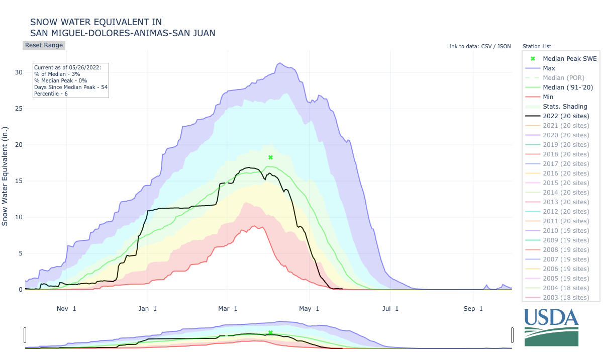
But the news isn’t all good for southern Colorado. The San Miguel, Dolores, Animas and San Juan Basin saw essentially no precipitation during last week’s storm and sat at 3% of median snowpack levels on Thursday, with just 0.1 inches of snow-water equivalent remaining. The melt-off has been among the worst the basin’s snowpack has seen over the past 30 years.

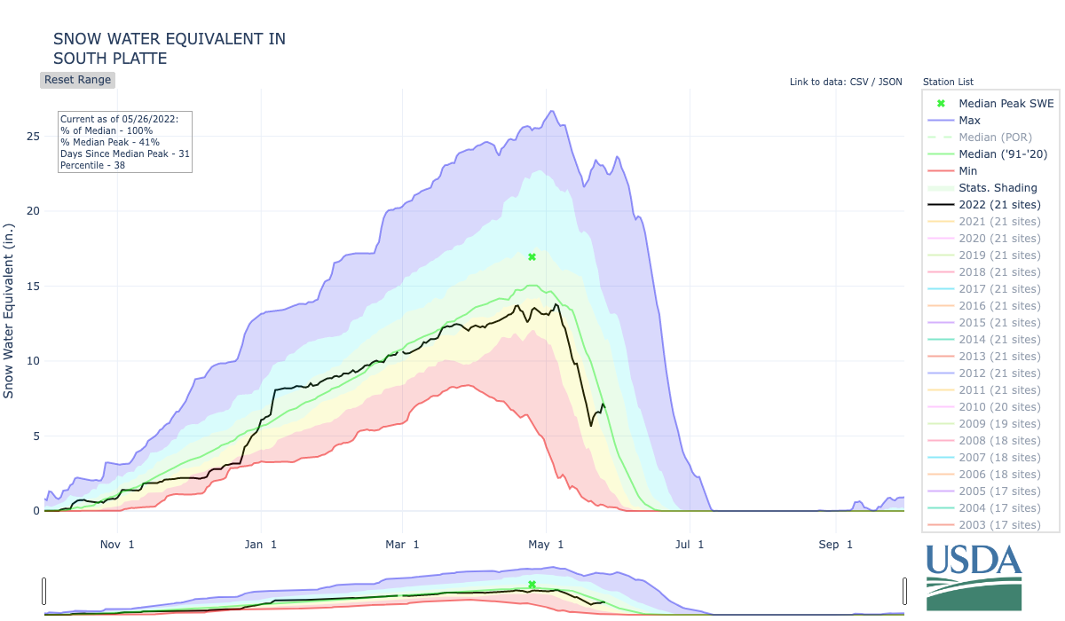
But the rest of the state is faring better. The heavy snow in the Front Range foothills boosted the South Platte basin’s snowpack to 100% of median levels for late May as of Thursday, adding more than 1.5 inches of snow-water equivalent over the past week.
The Yampa, White, and Little Snake basin was at 79% of median levels as of Thursday, while the Laramie and North Platte (86%), Upper Colorado Headwaters (61%) and Gunnison (56%) basins were all above 50% of median levels on Thursday.

Denver got 2.3 inches of snow at the airport in last week’s storm, and now has 1.77 inches of precipitation for the month so far – which is close to the 1.80 inches it normally gets by this point in May. For the year, the Denver area has gotten 4.72 inches of precipitation, compared to 5.13 inches in a normal year.
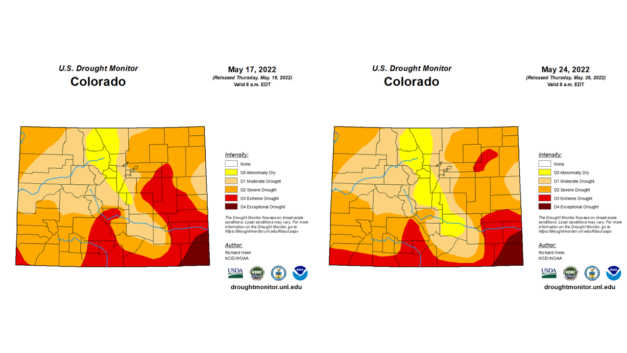
Last week’s storm helped drought conditions in eastern Colorado, but it got worse in certain parts of the southern half of the state compared to last Thursday’s U.S. Drought Monitor report.

Parts of eastern Arapahoe, eastern Elbert, northeastern El Paso, Lincoln, and western Kit Carson and Cheyenne counties moved from extreme drought back to severe drought. And parts of El Paso and Pueblo counties moved out of moderate drought to abnormally dry conditions, according to the U.S. Drought Monitor.
Other parts of Las Animas and Huerfano counties saw their drought conditions move from severe to moderate drought, and western Fremont County moved from extreme to severe drought.
But the three southwestern counties along the New Mexico border – Montezuma, La Plata and Archuleta – moved from severe drought to extreme drought conditions, and western Mesa County moved from moderate drought to severe drought over the past week.
For Friday and Saturday, the Denver area will see dry and warm conditions ahead of another round of possible precipitation Sunday through Tuesday.
But in southwestern Colorado, where red flag warnings were in effect Thursday, there is little precipitation in the forecast over the next week.
You can always watch 24/7 weather, radar and news updates on the free Denver7+ app on your TV.


